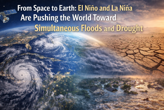
From Space to Earth: El Niño and La Niña Are Pushing the World Toward Simultaneous Floods and Drought
When the planet inhales and exhales through the Pacific, the world feels it. This rhythmic breathing—known to scientists as the El Niño–Southern Oscillation (ENSO)—can swing global weather from blistering droughts to catastrophic floods, sometimes at the very same moment in different corners of the globe. In today’s climate, these swings are amplified by a warming atmosphere that loads storms with more moisture, drives up evaporation over land, and primes entire regions for flash floods and megadrought in quick succession. Thanks to satellites, we can now watch these extremes take shape from orbit and trace their fingerprints as they travel from ocean to continent, from atmosphere to agriculture, from “abstract climate pattern” to the very price of bread.
ENSO 101: Why El Niño and La Niña Matter More Than Ever
El Niño occurs when surface waters in the central and eastern tropical Pacific are warmer than average. La Niña is the opposite: cooler-than-average waters in the same region. These phases push and pull on the Walker Circulation—a vast loop of rising and sinking air that steers tropical rainfall—and rewire atmospheric rivers and jet streams across the planet. The result is a global cascade: monsoons that arrive early or late, storm tracks that kink unexpectedly, and snowpacks that either explode with abundance or barely show up at all.
What makes this especially consequential in 2025 is that climate change has shifted the baseline. Warmer background temperatures supercharge the hydrological cycle, wringing more water from oceans and soils, intensifying downpours, and deepening dry spells. ENSO remains the drummer setting the beat; climate change turns up the volume.
The Satellite Revolution: Seeing Floods and Droughts Before They Strike
It’s one thing to speak of patterns; it’s another to see them. Modern Earth-observing satellites have transformed drought and flood monitoring from guesswork to precision. Instruments that measure sea surface temperatures (SSTs) reveal the warm and cool pools that define El Niño and La Niña. Microwave sensors map soil moisture day by day, indicating where fields are parched or primed for runoff. Radar altimeters track river levels even under cloud cover, and gravimetry missions detect changes in groundwater storage. Together, these datasets act like a planetary dashboard.
For farmers, water managers, and disaster planners, the lead time is invaluable. Early warnings based on satellite-derived SST anomalies can hint at a coming El Niño months in advance, while snowpack and soil-moisture maps flag regions likely to face either flash flooding or crop stress. In a world of compound risks, this foresight can be the difference between a harvest saved and a season written off.
Simultaneous Extremes: The New Normal of “Both-And” Weather
The uncomfortable truth is that El Niño and La Niña increasingly create “both-and” events: both flood and drought, both heat and deluge. Consider a strong El Niño year: the subtropical jet intensifies, channeling storms into the southern tier of North America and parts of South America. While one valley is inundated, the western Pacific—under subsiding, drier air—may endure rainless months. Flip the ocean to La Niña and the teleconnections reverse: deluges shift toward Southeast Asia and northern Australia, while the southwestern United States and parts of South America parch.
Yet even within a single region, the timeline can produce both extremes. Long droughts desiccate soils and vegetation, then an ENSO-shifted storm train arrives, dumping rain onto hardpan ground. Instead of soaking in, water races off, causing landslides and floods. The tragedy is not just the water we have or lack, but the timing: when water shows up all at once, it is as destructive as the months when it refuses to come.
Agriculture on the Front Lines: Yields, Prices, and Food Security
El Niño and La Niña teleconnections ripple through fields. Coffee in Brazil, wheat in Australia, rice in Southeast Asia, maize in the U.S. Corn Belt—each crop has a climate comfort zone, and ENSO can shove entire regions outside it. Warmer nights during El Niño events can hinder grain filling; poorly timed rains during La Niña can spoil harvest windows or foster pests and disease. Irrigated agriculture isn’t immune: reservoirs depend on snow and steady precipitation, both of which are disrupted by ENSO’s mood swings.
Food markets feel these shocks quickly. When drought grips one breadbasket while floods swamp another, prices react. Supply chains that were optimized for stability must now pivot for volatility: diversified sourcing, climate-smart storage, and better crop insurance matter as much as better seeds. From space, anomalies in vegetation indices flag stress weeks before eyes on the ground realize yields are in danger. This is proactive resilience—micro-adjustments made early rather than emergency measures after losses mount.
Water Systems Under Stress: From Reservoirs to Groundwater
Water managers juggle multiple time horizons at once: today’s demand, this year’s snowmelt, the decade-long trends in aquifer levels. El Niño and La Niña scramble those horizons. In El Niño years, wet-season downpours can spike reservoir inflows, forcing releases that may risk downstream flooding. During La Niña, stingy rains and higher evaporation pull levels down and push utilities to ration or pump more groundwater.
Here, satellite data has become a quiet revolution. Basin-scale snow-water equivalent maps help predict spring runoff; radar and optical satellites track reservoir extents; gravity missions reveal slow-motion changes in aquifers. When combined with ENSO forecasts, this data supports “dynamic operations,” where managers switch rules depending on the phase. The payoff is significant: capturing more water in wet months without overshooting flood-control limits, and conserving in dry months before reservoirs tip into crisis.
Cities and Infrastructure: Designing for Swing States of Water
Urban areas experience ENSO in concrete and steel. Intense El Niño storms can overwhelm combined sewer systems, while La Niña droughts stretch aging pipes and reduce hydropower output. Roads buckle in heat, then fail under flood scour. The fix isn’t a single mega-project; it’s a portfolio mindset: green infrastructure to absorb storms, distributed storage to smooth peaks, and smart metering to curb waste when rain retreats.
Crucially, urban planners now use “climate analogs” to stress-test designs. If your city’s ENSO future looks like a mashup of past monsoons and new heat records, you test for both. Heat-resilient materials, higher freeboard on bridges, pump stations with redundancy, and stormwater parks that double as public spaces—all help. The right design turns ENSO’s volatility from a hazard into a parameter.
Health and Humanitarian Risks: When Weather Becomes a Multiplier
Floods and droughts are not just hydrological tales; they are public health stories. Floods spike waterborne diseases, displace families, and disrupt care. Droughts concentrate pollutants, increase wildfire risk, and deepen food insecurity. ENSO can coordinate these threats at planetary scale—elevating dengue risk here, smoke exposure there, and malnutrition elsewhere—often in the same season.
Humanitarian agencies now blend ENSO outlooks with vulnerability maps to pre-position aid. Satellite-derived rainfall anomalies and vegetation stress indicators help forecast hotspots for displacement or crop failure. The more accurate the forecast, the more dignified the response—cash transfers before the crisis, not after; drought-tolerant seeds delivered early, not as a post-mortem.
Nature’s Ledger: Ecosystems Caught Between Deluge and Deficit
Forests, wetlands, and coral reefs are also ENSO witnesses. El Niño–related marine heat waves can bleach corals, while La Niña–enhanced rains may freshen estuaries and alter fish migration. On land, drought-primed forests are tinder; a lightning storm during a heat spike can ignite megafires whose smoke crosses continents. Then rains return and trigger postfire debris flows. The cycle is brutal, but not random. Managers now weave ENSO signals into prescribed burns, water releases for fish, and invasive-species control. Space-based fire detections and canopy moisture measurements give them the timing they need.
The Economics of Extremes: Why Insurance and Finance Care About ENSO
If you price risk for a living, ENSO is not trivia—it’s a line item. Crop insurers, municipal bond analysts, and reinsurers monitor Pacific SSTs like hawks. As both the frequency of extremes and the value at risk rise, traditional actuarial approaches get stressed. Index-based insurance products that trigger on satellite-observed rainfall or soil moisture can pay out quickly, bypassing lengthy claims processes. Carbon markets and nature-based solutions add a new layer: wetlands that absorb floods, forests that lower wildfire risk, and mangrove belts that blunt storm surge can be financed as resilience infrastructure with co-benefits for biodiversity.
What We Can Do Now: Practical Adaptation Steps That Work
This isn’t a story of helplessness. It’s a roadmap to smarter action:
Use ENSO-informed water rules. Update reservoir guides to switch between El Niño and La Niña playbooks, maximizing storage when safe and prioritizing flood space when storm odds rise.
Invest in data integration. Don’t just collect satellite streams—blend them with local gauges and models to create unified flood and drought dashboards for decision-makers.
Harden critical infrastructure. Elevate electrical substations in flood-prone corridors, expand culvert capacity in known atmospheric river paths, and add backup power for pump stations.
Diversify crops and calendars. Use seasonal climate forecasts to adjust planting dates, choose varieties suited to forecasted conditions, and expand soil-health practices that improve infiltration.
Strengthen early action systems. Tie humanitarian releases to objective triggers—rainfall deficits, vegetation stress, river heights—so resources move before headlines appear.
Protect and restore natural buffers. Wetlands, floodplains, and mangroves are proven, low-regret investments that store water in the wet and release it in the dry.
From Pattern to People: Why Storytelling Matters
Climate science can feel abstract until it touches daily life. A parent caring for a child with asthma during smoky La Niña summers, a farmer watching El Niño rains rot ripening fruit, a city engineer calculating storm return intervals that no longer return—these are the human faces of ENSO. Storytelling connects the planetary and the personal, translating “teleconnection” into plain language and actionable decisions. When leaders communicate the why behind preparedness—why a levy is raised, why a water restriction is tightened, why a park doubles as a flood basin—public trust follows.
Looking Ahead: Preparing for the Oscillation, Not the Average
The world we’re building must be compatible with swings, not just averages. That means shifting from “normal-year” planning to range-aware planning. It’s less about predicting the exact rainfall on a given Tuesday and more about designing systems that perform acceptably across a wider envelope. Satellites will continue to sharpen our view, models will extend our lead time, and communities will refine playbooks that move from forecast to action. ENSO will keep breathing in and out; our job is to breathe with it—anticipate the inhale, prepare for the exhale, and keep the most vulnerable out of harm’s way.
Final Thought: Space Eyes, Earthwise Choices
From space, the planet’s water story is legible: a warm stripe in the Pacific, a thirsty basin in the interior, a ribbon of storms barreling toward a coast. On Earth, those signals become choices—what to plant, where to build, when to conserve, how to protect. El Niño and La Niña will continue to nudge us toward simultaneous floods and droughts; the question is whether we meet those nudges with improvisation or preparation. With better data, smarter infrastructure, and compassionate policies, the answer can be preparation—anchored in science, accountable to people, and resilient in the face of a climate that now speaks in superlatives.
SEO Keywords (single paragraph): El Niño, La Niña, ENSO, climate change impacts, global warming, extreme weather events, simultaneous floods and drought, satellite imagery climate, soil moisture monitoring, atmospheric rivers, drought forecasting, flood risk management, climate resilience, disaster preparedness, water resource management, reservoir operations, snowpack and runoff, agriculture and climate, food security, crop yields El Niño, La Niña teleconnections, Pacific sea surface temperatures, jet stream shifts, urban flooding solutions, green infrastructure, groundwater depletion, climate-smart agriculture, early warning systems, humanitarian response, wildfire risk, coral bleaching, biodiversity and climate, nature-based solutions, climate risk insurance, index insurance, hydrological cycle intensification, climate adaptation strategies, sustainable water management, Earth observation satellites, remote sensing for drought, flood mapping, ENSO forecast 2025, climate blog, environmental news, science-based climate analysis, SEO-optimized climate article.