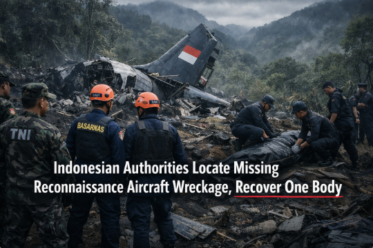
Indonesian authorities find the wreckage of a missing reconnaissance aircraft and recover one body
Makassar, South Sulawesi — January 19, 2026. The mountain keeps its secrets until the weather loosens its grip. On the fog-streaked slopes of Mount Bulusaraung, Indonesian rescue teams finally located the broken anatomy of a fisheries reconnaissance aircraft—an ATR 42-500 turboprop chartered for maritime surveillance—scattered down a ravine so steep that even the wind sounded cautious. Among twisted spars, passenger seats, and torn fuselage, searchers recovered one body, then paused, recalibrated, and returned to the meticulous labor of finding answers in terrain that punishes hurry. (Reuters)
The flight’s story began with routine purpose. According to officials, the Indonesia Air Transport plane departed Yogyakarta on January 17, 2026, bound for Makassar’s Sultan Hasanuddin International Airport, ferrying three officials from the Marine Affairs and Fisheries directorate and a crew on a surveillance assignment. Somewhere near the Maros region, minutes from destination, the aircraft fell out of contact. Controllers had reportedly advised a course correction as the approach alignment drifted, a reminder that bad weather and mountains have a way of bending the geometry of flight. Within hours, the country’s national search-and-rescue agency, BASARNAS, activated one of its most dangerous kinds of hunts—part patience, part physics, part prayer. (AP News)
Early dispatches, amplified by the echo chamber of social media, counted 11 people on board. Investigators later adjusted the figure to 10, illustrating how first-day numbers often shift as manifests, charter records, and duty rosters are reconciled. What has not changed is the grim certitude of the first recovery: a victim found down a ~200-meter ravine, bringing the first tangible measure of loss to families in Makassar and across the archipelago. The remaining occupants—colleagues and loved ones—were, as of this writing, still the subject of an intense, multi-agency search throttled by fog, sheer angles, and the sort of mud that eats boot treads. (Reuters)
A reconnaissance mission with civilian stakes
Labeling this aircraft “reconnaissance” risks conjuring spy-novel imagery, but in Indonesia the term is often admixed with the practicalities of governing a 17,000-island nation. Fisheries surveillance flights matter: they spot illegal trawling, coordinate with patrol boats, and help protect coastal livelihoods from exploitation. That is to say, the mission was not abstract. It was a flight stitched to food security, sustainable waters, and the rule of law offshore. The ATR 42-500, designed for short runways and regional hops, is a workhorse in such roles; in this case it flew under a charter to support the Directorate General of Marine and Fisheries Resources Surveillance. When such an airplane goes missing near a mountain massif, the ripples spread beyond the cockpit and cabin to fish markets, coastal villages, and ministry offices that depend on the data such sorties collect. (Wikipedia)
Where weather, terrain, and timing intersect
Aviation investigators talk about “controlled flight into terrain” (CFIT), a sterile phrase that stands in for harrowing seconds when a crew is flying, instruments may be obedient, and yet the earth arrives faster than expected. Early commentary from officials pointed toward an impact along a mountainside while the aircraft was on approach in cloud and fog, conditions that compress visibility and erode options. No conclusion is yet official; Indonesia’s National Transportation Safety Committee (NTSC) will spend months testing hypotheses against a chain of evidence—flight path data, cockpit communications, maintenance logs, and if possible, information from the flight recorders. The goal is unambiguous: prevent the next accident. For now, rescuers on the ground have reported debris fields with fuselage sections and a tail assembly fallen downslope, the kind of geometry consistent with a high-energy impact on rugged terrain. (Reuters)
The choreography of rescue
Search and rescue in South Sulawesi’s mountains is not a linear operation; it’s choreography under constraint. BASARNAS teams, soldiers, police, and local mountaineers have been moving in weather windows, ferrying ropes, litters, cutting tools, and radios up trails that are trails only by courtesy. Helicopter crews have overflown the slopes, their eyes tuned for the unnatural angles of airplane wreckage against green—the tailcone here, a window frame there, the pale flash of a seat cushion. When ground teams confirmed the site and recovered the first body, they did so in a ravine so deep it converted minutes into hours. Leaders in Makassar have spoken of deploying more than a thousand personnel to widen the search, a scale-up that reflects both the topography and the urgency of bringing families definitive news. (CNA)
Counting the cost, carefully
In the news cycle’s haste, numbers can become a kind of theater. Some outlets repeated “11 aboard” as definitive; others flagged the revision to 10 by authorities after cross-checks. Responsible coverage carries both facts and humility: one body recovered, several still unaccounted for; wreckage located on January 18, search ongoing January 19; cause under investigation. In a tragedy that unfolded over days, the ethical thing is to hold space for verified information and avoid filling gaps with guesswork. Families watching updates deserve signal, not noise. (Reuters)
The human dimension behind the headline
Aviation units don’t staff themselves with abstractions. Every seat on the manifest belonged to a person—pilots logging duty days, a flight attendant who knew a dozen ways to lower a passenger’s blood pressure during turbulence, technicians whose hands still smelled faintly of hydraulic fluid after preflight, and fisheries officials who carried maps that turn blue water into policy. When rescuers speak of carrying someone up a slope or marking a grid for the next morning’s push, they are doing so with the understanding that families will measure time in breaths until the phone rings. That’s why the retrieved remains matter beyond the forensic; they are the first delivered truth in a storm of uncertainty. (AP News)
What we know about the aircraft
The ATR 42-500 is a rugged twin-turboprop frequently used across archipelagos for regional transport and specialized missions. The unit involved in this crash, PK-THT, had a long service life and a familiar profile over Indonesian skies. Maritime surveillance configurations may include observation windows, communications gear, and equipment mounts for sensors. Investigators will be looking at whether weight, balance, mission gear, maintenance state, and crew duty times played any role—routine questions that often produce non-dramatic, yet crucial, answers. Aircraft age is frequently cited in public debates, but age alone rarely causes accidents; rather, it’s maintenance quality, compliance with airworthiness directives, and the interplay of human factors and environment that typically determine outcomes. (Wikipedia)
Why maritime patrol flights matter to Indonesia
Indonesia’s exclusive economic zone (EEZ) is a vast canvas. Surveillance flights help deter illegal, unreported, and unregulated (IUU) fishing, support interdiction operations, and coordinate with patrol vessels that can’t be everywhere at once. A single sortie can spot a suspicious fleet, vector a cutter, and document violations that hold up in court. Losing an aircraft in this role is more than an operational deficit; it’s a stress fracture across a maritime security strategy calibrated to protect fish stocks and coastal communities. In the shorter term, other assets will backfill the mission profile—fixed-wing, rotary-wing, and surface patrols—but the psychological effect on crews and planners is real. (Reuters)
What comes next: investigation, accountability, prevention
Once the NTSC secures the flight recorders (if recoverable in the ravine) and consolidates field reports, the team will reconstruct the accident sequence. Expect a preliminary report in a matter of weeks that outlines factual information without analysis, followed by a technical final report many months later. In the interim, authorities may issue safety recommendations—procedural adjustments to approach paths in poor visibility, crew training refreshers on terrain awareness, or equipment guidance for operators flying specialized missions into mountainous airfields. Each recommendation is a lever designed to move the probability of recurrence in the right direction. (Reuters)
The media’s role: getting the details right
Coverage of aviation accidents often oscillates between clinical jargon and melodrama. But accuracy is its own kind of compassion. Where official counts are in flux, cite both the earlier figure and the authoritative revision. Where crash causes are not yet determined, say so—clearly. Where terrain and weather impose constraints, explain why helicopters can’t always hover over a vertical ravine or why nightfall halts rope work no matter how urgent the mission feels. These specifics earn trust, especially from readers who are learning in real time (and from families who will remember who told the story carefully). (AP News)
A community that climbs together
In Indonesia, disasters are not borne by one agency alone. Local hikers, volunteer radio operators, and villagers who know every contour of Bulusaraung’s folds often arrive with the kind of local knowledge you can’t brief in. When the first body was retrieved, it was because coordination met courage in a place where helicopters couldn’t do the last meters and GPS offered only a nudge. The rescuers who tie off a litter to a tree root and move inch by inch embody a national ethos: when geography turns hostile, community becomes tactic. (CNA)
A moment for empathy—and patience
It is tempting to sprint to conclusions, to insist on a single tidy narrative. Aviation resists simplicity. Weather layers with terrain; human decision-making intersects with instrument readings; a routine approach becomes an outlier in the span of seconds. What we can do in the meantime is hold space for the families, honor the work of the search teams, and respect the investigative process. Today, the most reliable facts are these: wreckage located on Mount Bulusaraung, one body recovered, search operations ongoing, and cause under investigation. Everything else belongs to a methodical process where each newly recovered item—seat frame, engine part, a segment of fuselage—sheds another lumen of light on what happened in the clouds above South Sulawesi. (Reuters)
Sources and verification notes
Key details in this report—location and date of wreckage discovery, confirmation of one body recovered, evolving occupant count, route and aircraft type—come from Reuters, Associated Press/ABC, and regional outlets providing on-scene updates as of January 18–19, 2026. Numbers may continue to evolve as authorities complete identification and recovery. (Reuters)
SEO Keywords (single paragraph): Indonesian plane crash, ATR 42-500 crash South Sulawesi, Mount Bulusaraung wreckage, Indonesia Air Transport PK-THT, fisheries surveillance plane Indonesia, reconnaissance aircraft crash Indonesia, Makassar plane missing, BASARNAS search and rescue, NTSC investigation Indonesia, maritime patrol aircraft Indonesia, Yogyakarta to Makassar flight, South Sulawesi aviation news, Indonesian air safety 2026, one body recovered Indonesia crash, Indonesia aviation accident today, Indonesian authorities find wreckage, debris found near Maros region, Sultan Hasanuddin International Airport approach, plane crash investigation Indonesia, latest Indonesia news.